Introduction
Are you lost in London? Tracking down your London ancestors and tracing the various addresses where they lived can be a complicated exercise, particularly in the East End of London where many neighbourhoods have changed beyond recognition. Slum clearance, bomb damage and the renaming of streets can all make it difficult to pinpoint exactly where one’s ancestors were living. Fortunately though, there are a number of resources that are invaluable for mapping London ancestors. In this article, I will be looking at how I have used them to place my husband’s London ancestors, the Woodcocks, in the context of their local environment.
Methusalem Woodcock, a shipwright, arrived in London on a boat in the early 1860s. He was from the Isles of Scilly, which are situated off the southern most tip of Cornwall. No doubt he went to London to seek better opportunities and prospects, finding work on one of the many ships from around the world that docked in the Thames. Not long after coming to London, he met his wife, Mary Ann, née Ford, a native East Ender who had been born in 1843 in the dockside parish of Wapping. Her father, William Ford, along with his second wife and their young family, had emigrated to New Zealand in May 1863 leaving Mary Ann behind. Mary Ann’s uncle, John Ford, and brother, William John George Ford, had already emigrated to New Zealand a few years previously. Mary Ann had decided not to go, perhaps because she had already met Methusalem and did not want to be parted from her sweetheart. You can find further details of the story here: https://genealogyjude.com/2020/06/13/the-tale-of-the-mathematical-instrument-maker-part-3/
Mary Ann Ford was living with her maternal uncle and aunt, Andrew Truby, a sailmaker, and his wife Hannah, on Antcliff Street, in Mile End Old Town, which is situated just north of Commercial Road, the great artery that linked the City to the East End, at the time of the 1861 census. She and Methusalem decided to get married at the nearby church of Christ Church, Watney Street:

http://www.stgitehistory.org.uk/chchwatneystreet.html

http://www.stgitehistory.org.uk/chchwatneystreet.html
Christ Church, Watney Street, was a satellite church to St George in the East. It was consecrated in 1841 but destroyed by a bomb just hundred years later in the Second World War. The couple were both baptised as adults on the same day, Sunday September 11th 1864, before marrying two Sundays later on September 25th 1864. Methusalem gave his address as Thomas Street and Mary Ann gave her address as Commercial Road.
Methusalem and Mary Ann’s first child, Hannah, was born in Mile End Old Town on May 29th 1866 at 4 Patterson Street. Mary Ann was still living at this address with her daughter, Hannah, and her uncle and aunt, Andrew and Hannah Truby, when the 1871 census was taken, though Methusalem was away from home. Perhaps he was away at sea, working on a ship.
To locate and pinpoint these various addresses, I consulted the Ordnance Survey map collection of the National Library of Scotland and found a six inch to the mile map of Stepney that was surveyed between 1868 and 1871:

Blue arrow – Antcliff Street
Yellow arrow – Thomas Street
Green arrow – Patterson Street
Series: Ordnance Survey. Six-inch to the mile
Surveyed: 1868 to 1873
Published: 1880
via http://www.maps.nls.uk
The above map shows the addresses that are associated with the family for this period, all situated within a mile or so of each other, in the vicinity of Commercial Road, as it passes through the parishes of St George in the East and Stepney. As mentioned previously, the church of Christ Church, Watney Street, was bombed during the Second World War and was destroyed. However, I was rather sobering to discover that neither Antcliff Street, Thomas Street nor Patterson Street exist today, the roads have been totally obliterated. I have marked a modern map of this area with arrows that correspond with the historic Ordnance Survey map, to show the previous location of the streets:

Blue arrow – Antcliff Street
Yellow arrow – Thomas Street
Green arrow – Patterson Street
Area around St George in the East/Stepney via http://www.maps.google.co.uk
Victorians tended to move around a lot in cities, as most people rented. Since censuses are only taken every ten years, they could have lived at several addresses in between. One way of discovering where a person or family was resident is through a GRO certificate that provides an address, perhaps if a child was born in the intervening period. Another alternative is to look at electoral registers. The 1867 Second Reform Act enfranchised part of the working class for the first time. The Act was based on a property qualification and granted the vote to all householders in the boroughs, as well as lodgers, who paid rent of £10 a year or more. This roughly doubled the electorate in England and Wales from one million to two million (out of a population of seven million adult men).
I found out where Methusalem and Mary Ann Woodcock were living in the 1870s by looking at London Electoral Registers, which have been digitised on Ancestry (http://www.ancestry.co.uk). Electoral registers for 1873 and 1875 record Methusalem/Methuselah Woodcock at 32 Gough Street, in the parish of St Anne’s Poplar, further east from where the family were living previously. It looks like he had moved down the road, as electoral registers for 1876 and 1877 record his address as 64 Gough Street, (unless the road was renumbered in the intervening period). Gough Street consisted of terraces of houses with shops on the ground floor that were built mainly in the 1860s.
If an ancestor had a trade, you may also be able to discover the address where they were living by looking at a trade directory, (though one should remember that it will always be a little out of date by the time it was published). A Post Office Directory for London, published in 1875, gives the same address of 64 Gough Street for Methusalem Woodcock, but he is listed as running a chandler’s shop, selling supplies and equipment for ships and boats. William Ford, Mary Ann’s father, had been a mathematical instrument maker, so Mary Ann had probably grown up assisting her father in his shop. Perhaps she had persuaded her husband to down his carpentry tools so they could run a business together, or perhaps she was in charge of the shop whilst Methusalem continued to work as a shipwright.
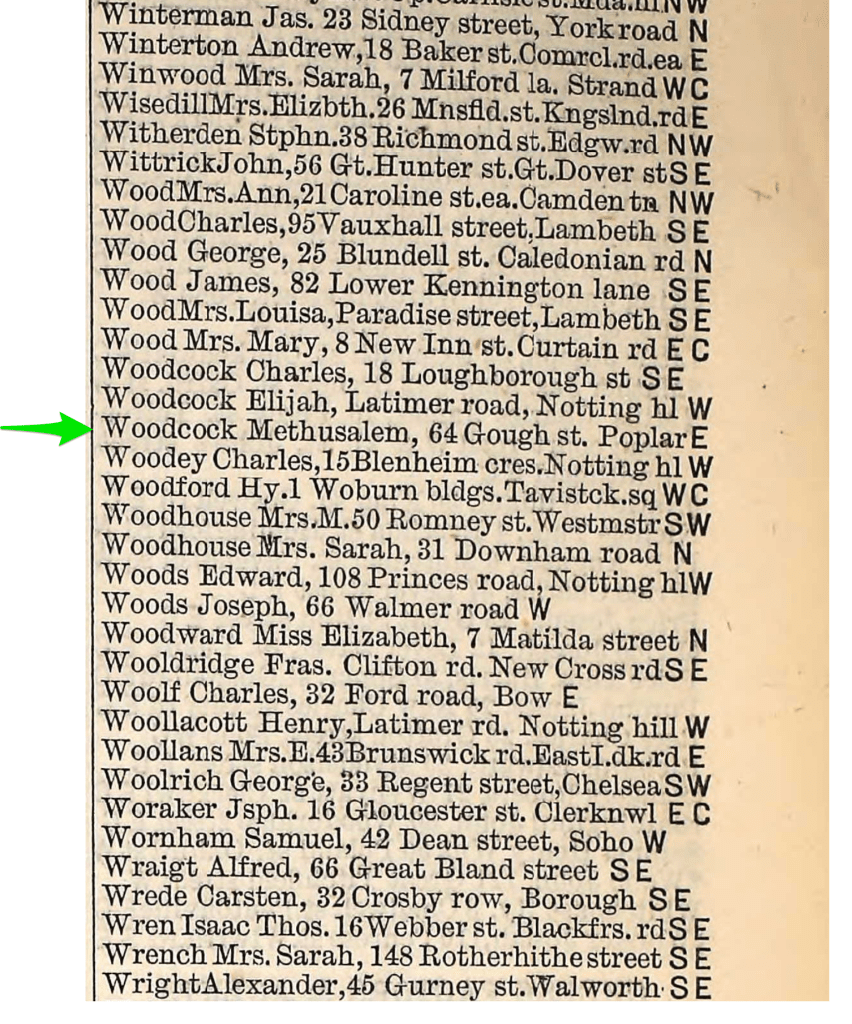
By looking at the various households who were living on Gough Street in the 1871 and 1881 censuses, you can get a good idea of the neighbourhood and the occupations of its residents. For example, there were several shipwrights and joiners living on Gough Street in both censuses. Gough Street was the name of the western end of Thomas Street in Poplar. Today, the street has disappeared but there is a pedestrian walkway, Gough Walk, that largely follows the path of the old street.
Methusalem and Mary Ann had one further child, Stanley Vernon, born at 723 Commercial Road, Limehouse, on August 30 1877. Sadly, the house that previously stood at 723 Commercial Road is no longer in existence. It has now been replaced by a modern block of flats. However, I think it is very likely that it looked like the houses seen below in a terrace spanning 703-711 Commercial Road, just a short distance down the road:

via http://www.maps.google.co.uk
To find out more about the home where an ancestor lived, the 1911 is well worth consulting, as this census required householders to state the number of rooms in their house. Fortunately, you can use an advanced search on the website of FindMyPast (http://www.findmypast.co.uk), to search by address, rather than by name. I found that 723 Commercial Road had two families resident there in 1911. The Castle family recorded that there were eight rooms in their house, whilst the Dance family, in contrast, only occupied two rooms. It therefore looks likely that the Dance family were living in the basement rooms, whilst the Castle family lived in the rest of the house. Next door at No. 725, lived Mr Welch, a physician and surgeon, with his wife and three servants; they had the whole property, all ten rooms, to themselves.
Sometime between Stanley’s birth and the taking of the 1881 census on April 5th 1881, the family moved to 81 Locksley Street in Limehouse:

Methusalem Woodcock is here recorded as George, the name of his deceased brother who had died in 1867. Unsurprisingly perhaps, he may not have been that fond of the name Methusalem. George and Mary Ann were living with their two children, Hannah Lilian, aged 14, who was blind, and Stanley Vernon, who was then aged 3. A couple named Henry and Hannah Hart were also lodging with them.
The map below shows the addresses where the Woodcock family had lived from at least 1873:

Blue arrow – Cotton Street (Locksley Street)
Orange arrow – 723 Commercial Road
Series: Ordnance Survey. Six-inch to the mile
Surveyed: 1868 to 1873
Published: 1880
via http://www.maps.nls.uk
Locksley Street, previously known as Cotton Street, was part of the Cotton Estate which covered seventy four acres in Bow, Mile End and Limehouse. Originally, this area in the northern part of the parish of St Anne’s, Limehouse, had been fields (as one can see by consulting earlier maps), but between the mid-1850s and 1860s, twenty seven streets of terraced houses were built in the area, including Cotton Street. There was a lot of development, as workers who had flocked to this burgeoning industrial area needed to be housed. Locksley Street was situated just south of Bow Common, in an area of land between Regent’s Canal and Limehouse Cut. I have marked it on the map below with a red x:

Series: Ordnance Survey. Six-inch to the mile
Surrey Sheet III.NE
Revised: 1893 to 1894, Published: 1898
https://maps.nls.uk/view/101436346
Though the Grand Canal Junction, which opened in 1801 at Paddington, linked London with the rest of the country’s network, it didn’t reach far enough to connect up with the seaborne trade of the River Thames. The canal was therefore extended nine miles through Limehouse when Regent’s Canal was dug in 1820. It was especially used for transporting coal by barge, which had been unloaded from colliers from the north-east of England that had docked in the Thames. Some trade was lost with the coming of the railways in the 1840s but the dock was expanded to accommodate larger ships and more diverse cargoes, such as blocks of Norwegian ice. The canal passed under Commercial Road from Regent’s Canal Dock, now known as Limehouse Basin:

The entrance gates to the Regent’s Canal at Limehouse in London, 1823.
Originally produced for Thomas Hosmer Shepherd’s series “Metropolitan Improvements; or London in the Nineteenth Century” (London : 1827-1830).
https://commons.wikimedia.org/wiki/File:Regent%27s_Canal_Limehouse1823.jpg
To the east of Regent’s Canal was Limehouse Cut, the oldest canal in London, which ran close to the southern end of Locksley Street. Only 1.4 miles long, it was first dug in 1770 as a short cut for barges to link up with the River Lea from the Thames at Limehouse. Over time it became very polluted with sewage and chemicals from the many nearby factories but by the time the Woodcocks arrived in the area, it had been cleaned up considerably.
The Woodcock family home was 81 Locksley Street, the penultimate house on the east side of Locksley Street, just before Clemence Street, (marked on the map below with a red x). The school that young Stanley attended, Thomas Street Board School, (opened in 1876) was only a short distance away, (marked on the map with a green tick). He must have crossed the tram tracks of the busy Burdett Road to get there:

Green Tick marks the location of Thomas Street Board School where Stanley V. Woodcock was educated until he left school in 1891
Ordnance Survey Large Scale Town Plan
London – London VII.70
Revised: 1893 – 1895, Published: 1895. via http://www.maps.nls.uk
At the southern end of Locksley Street was Copenhagen Oil Mills, a factory that crushed oil from seeds:
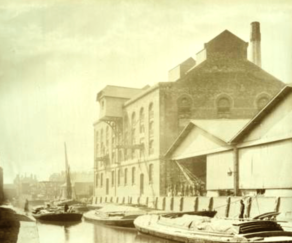
By Unknown author – Historic England, Public Domain, https://commons.wikimedia.org/w/index.php?curid=91414142
The map below is one of eleven sheets in an atlas produced to aid insurance companies in assessing fire risks. From this you can see the large amount of commercial activity in the neighbourhood, with timber yards, coal sheds, oil mills, lead works, cooperage and saw mills on the wharfs alongside the nearby Limehouse Cut. Perhaps Methusalem (George) worked as a shipwright on one of these. It must have been a noisy environment for the residents of Locksley Street. The southern end of Locksley Street, (recorded here as Cotton Street), is on the left hand side of the map:
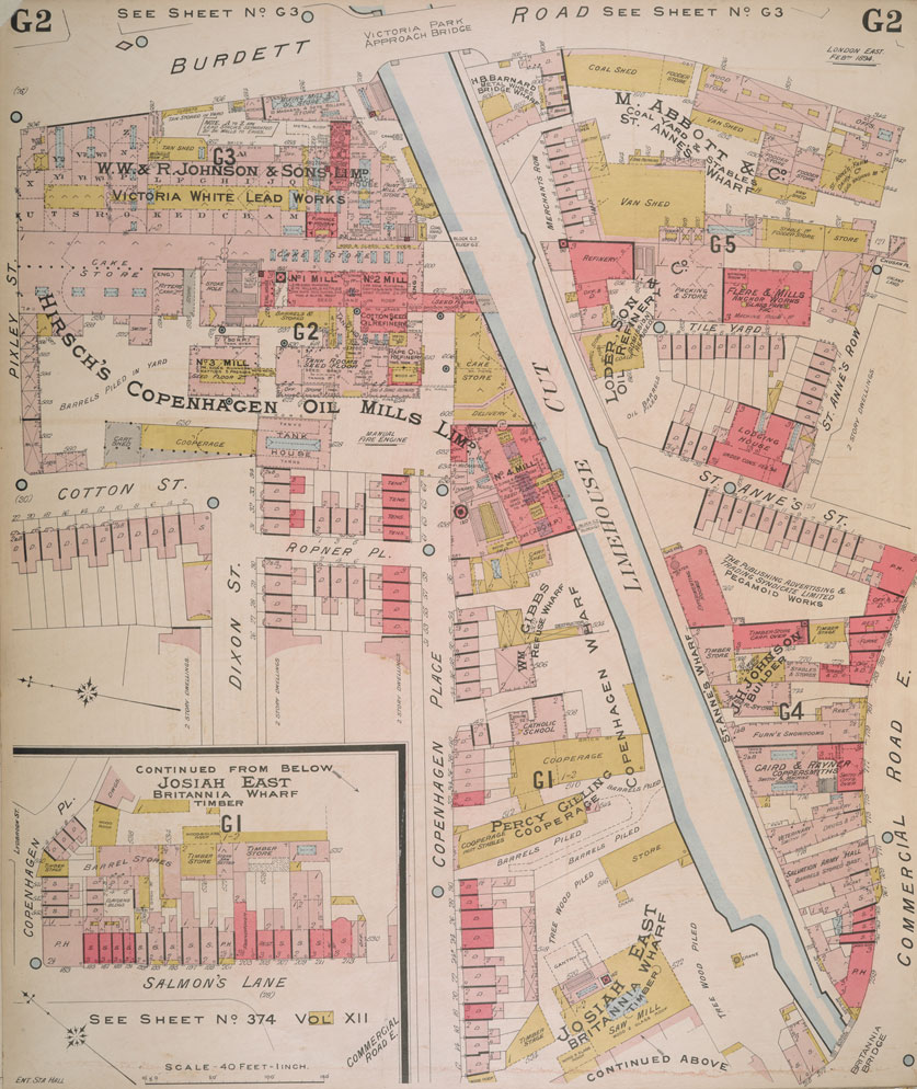
©The British Library Board
The Woodcock family were still at 81 Locksley Street when the 1891 census was taken and had a lodger, Arthur Underwood, a tailor’s traveller, living with them:

Methusalem (George) Woodcock appears in the Electoral Registers for 81 Locksley Street every year until 1895, so the family had lived there for at least fourteen years.
To find out more about this area of Limehouse where the Woodcock family lived, I consulted Charles Booth’s Poverty Maps, which were produced in 1898/9 to gather information on the social and economic status of Londoners. Streets were classified according to the status of the occupants, with seven categories ranging from “Lowest class, vicious semi-criminal” to “Upper-middle and upper classes, wealthy”. From the map below, you can see that the light red hatching classified Locksley Street, (marked with a red x), as a street where the residents were “Fairly comfortable, good ordinary earnings”. Judging by the census returns, lots of the residents of Locksley Street were employed at the docks and in the nearby engineering and ship building yards:

All twelve maps covering London (though not the City), are available at: https://booth.lse.ac.uk/map/. A slider on the website enables you to switch between the Poverty Maps and modern maps of the same area. There are also some Notebooks produced by Charles Booth’s researchers. One of these covers the inmates of Stepney Union workhouse, and a report was produced on one of the residents of Locksley Street, Sarah Ann Daley, who lived at 108 Locksley Street:

https://booth.lse.ac.uk/notebooks
Sarah Ann Daley of 108 Locksley Street, a widow was interviewed and all sorts of information, invaluable to family historians, was written down about her life. Sadly, her husband, a fireman on a National Line Steamer, had fallen sick in August 1883 with a prolonged illness from which he never recovered: eventually he had died in April 1884. As a result, the family had fallen on hard times. The children had been admitted to the workhouse and Sarah Ann’s young baby had died in April 1885. It is a tragic story. I wonder whether the Woodcock family knew their neighbour well.
A bomb fell on Locksley Street in 1941, which damaged many of the houses. After the War, others were cleared away and council housing was built, forming the Locksley Estate in the late 1950s as part of post-war reconstruction in the area. The site of 81 Locksley Street is now part of Mile End Park, the whole area forming the Brickfield Gardens Conservation Area:
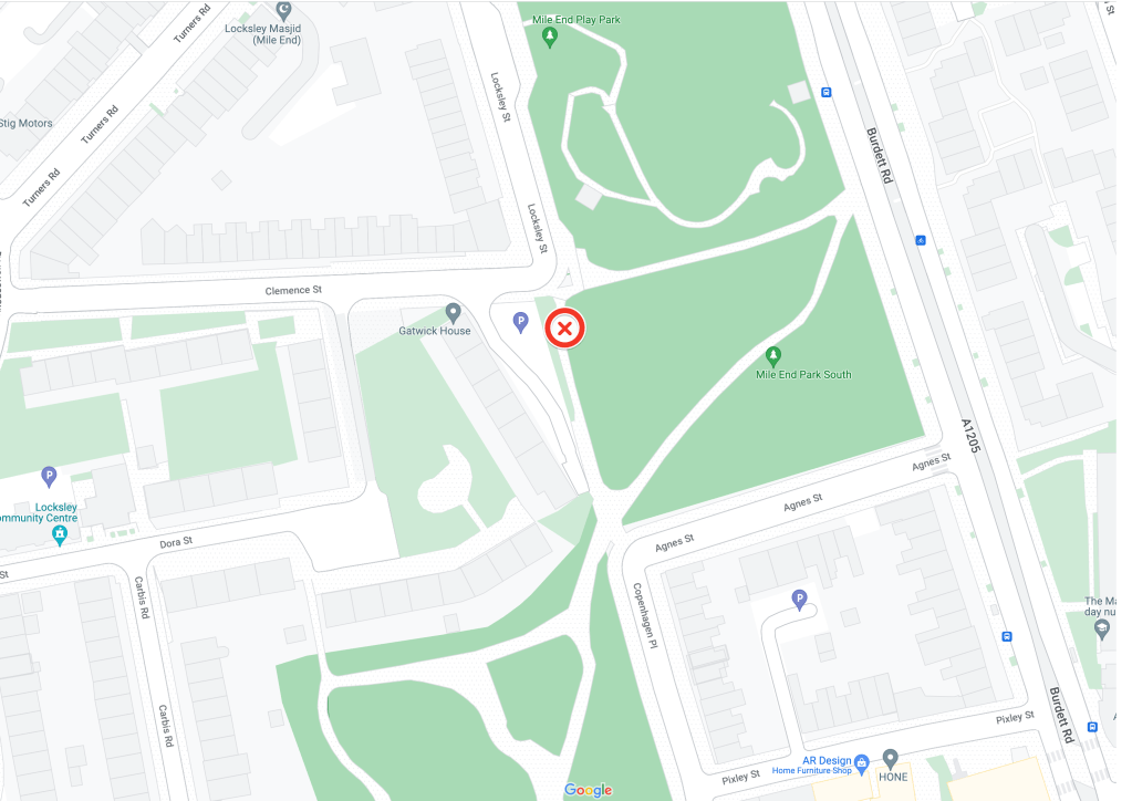
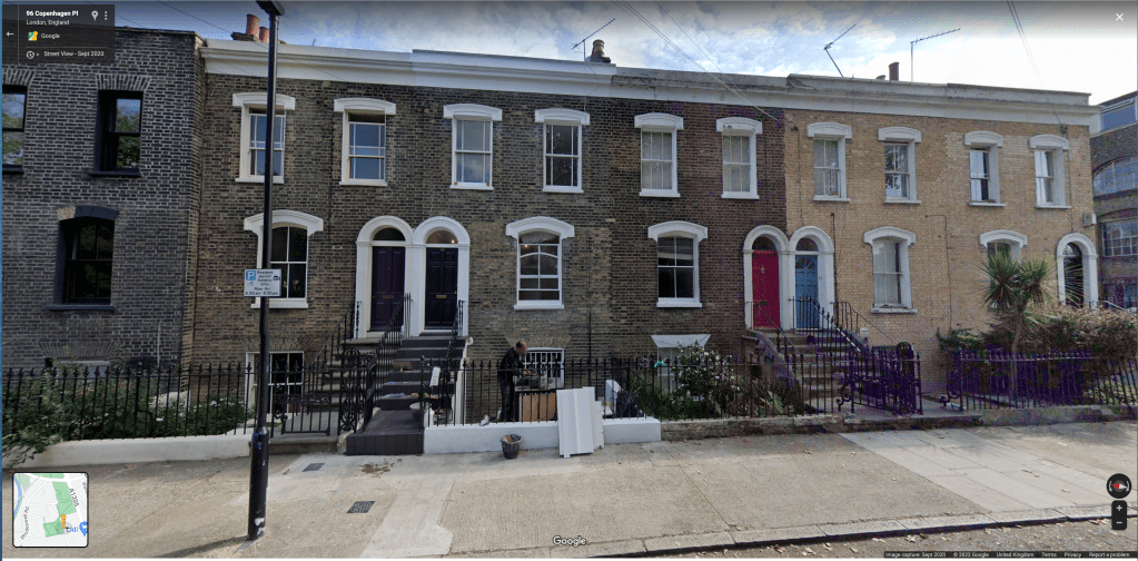
The red x on the above map shows the spot where 81 Locksley Street formerly stood. It is now part of the park. However, a terrace of twelve houses still remains at Copenhagen Place, which was formerly situated on the eastern side of Locksley Street, between Agnes Street and Pixley Street:
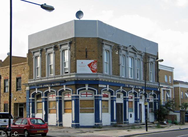
The local pub, The Prince Alfred, which was nearly opposite the Woodcock family home at 86 Locksley Street, has also survived though it is now closed and has been turned into flats:
© T.C.
Although I now had a good idea of the appearance of 81 Locksley Street, I was delighted to find an actual surviving photograph of the terrace of houses that contained 81 Locksley Street, before they were demolished, on the website of the London Picture Archive:
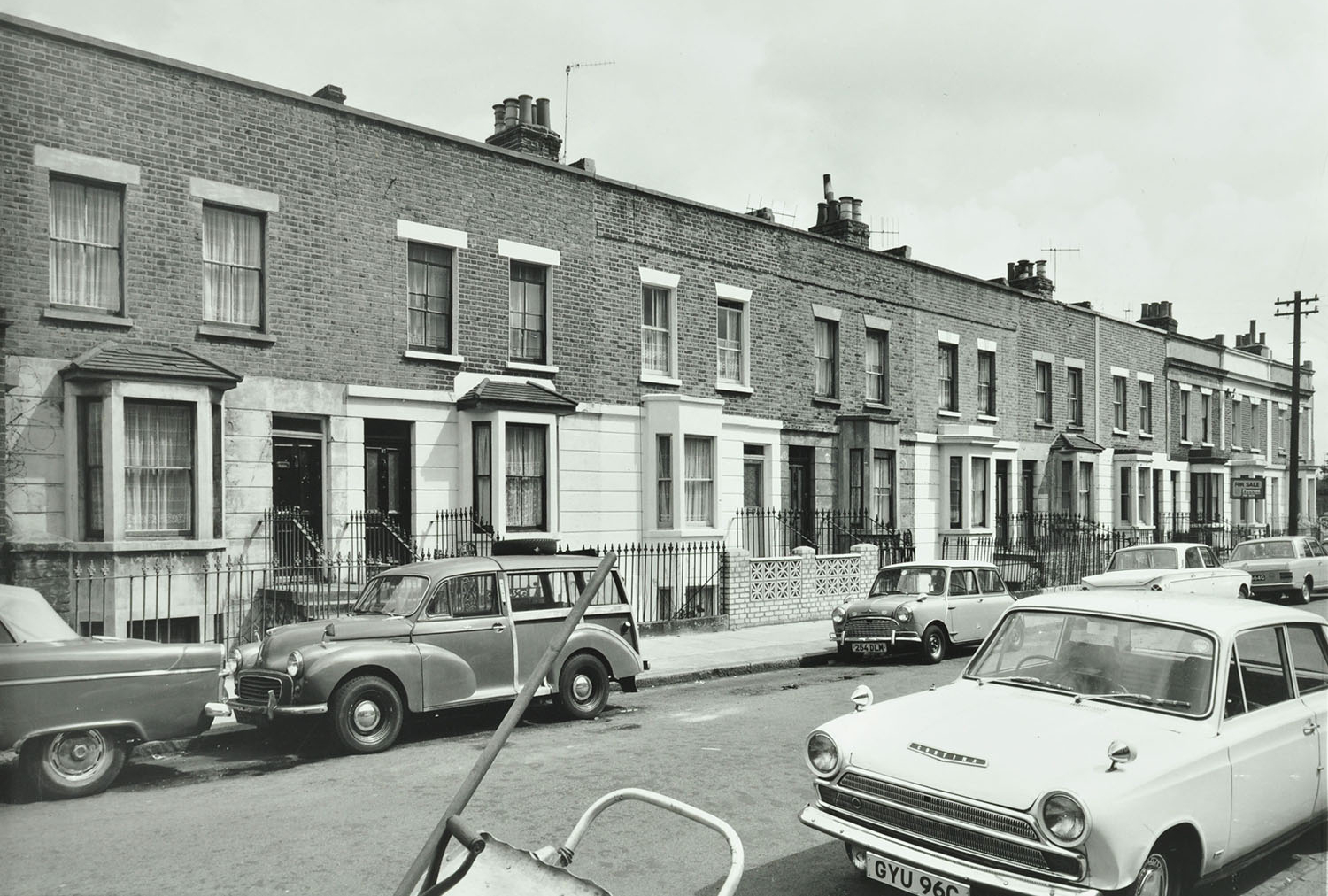
It is interesting to see the small details of the houses: the box bow windows, the stone steps leading up to the smart front doors with rectangular fan lights, and the iron railings with finials. This was the Woodcock family home for many years, until the family moved out to Essex in the late 1890s.
Conclusion
By looking at a variety of maps and other resources such as electoral registers, trade directories and photo archives, it has been possible to discover exactly where Methusalem and Mary Ann Woodcock lived after their marriage in 1864. It has also been possible to put together a picture of their local environment. Given the amount of change and reconstruction in this area of the East End, it would be impossible to pinpoint these places today without this kind of research. Now armed with this information, l hope to have the opportunity to visit this fascinating area of London in person, and walk in their footsteps.
N.B.
If you have a Diamond subscription to The Genealogist https://www.thegenealogist.co.uk/, you can use their Map Explorer tool to link records with both historic and modern day maps. The 1871 and subsequent censuses are linked, along with the Charles Booth poverty maps and other record sources. This makes it straightforward to pinpoint the location of a property in London on a map.
resources
The National Library of Scotland website has a huge variety of Ordnance Survey maps and town plans that can be viewed for free:
A very clear 1868 map of this area of London can be viewed on the excellent Mapco website:
https://london1868.com/weller46.htm
Old Maps Online lists many different types of map for a specific place – includes Fire Insurance Maps:
https://www.oldmapsonline.org/
The Georeferencer website provides a useful tool to play around with interactive maps:
https://www.georeferencer.com/
Detailed information on St George in the East can be found on the parish website:
https://www.stgitehistory.org.uk/chchwatneystreet.html
London Picture Archive – Over 250,000 images of London from the collections at London Metropolitan Archives and Guildhall Art Gallery can be viewed here:
https://www.londonpicturearchive.org.uk/
Charles Booth’s London Poverty Maps and Police Notebooks can be explored here:
A London Inheritance – A wonderful blog full of photographs and maps telling the history of different areas of London:
https://alondoninheritance.com/
A very useful website that provides both the present and former names of streets in London, 1857 – 1929:
https://www.maps.thehunthouse.com/Streets/New_to_Old_Abolished_London_Street_Names.htm#G
Layers of London – This is a map based website developed by the Institute of Historical Research. Find out how an area has changed over time with the map overlays and look at the pins to discover more about specific buildings and people.
https://www.layersoflondon.org/
If you would like to know more about Hannah Lilian Woodcock, who was blind from childhood, please read my article, Ancestors who were Blind:
Stanley Vernon Woodcock had an exciting life, travelling to Colombia as a small boy and setting himself up as a merchant. You can read more about him in Special Relationships:
© Judith Batchelor 2023


The time you have spent looking at the geographical context brings so much colour to what could otherwise just be a set of addresses and dates. I’m sure that by walking in these areas you’ll feel an even more tangible connection to your ancestors.
I noticed that the Woodcocks moved from Limehouse to Essex in the 1890s. My ancestor Detective Inspector George Read and his family also moved from Mile End to Southend in the 1890s. I wonder if that move was driven by rail connections, new suburban housing, decreasing standard of living in East London, or some other factors.
Do you ever use the Layers of London website? I’ve used it but I don’t find it intuitive. Unfortunately, to read their ‘how to’ guide requLires a subscription to a 3rd party website.
LikeLiked by 1 person
With London, it’s a really good idea to do your homework first before visiting. It’s a shame that some of the new post war housing is so unappealing but one has to be careful not to romanticise the past. The slum housing must have been terrible.
Moving to Essex seems a well-worn path for EastEnders. Places like Southend were only a train ride away and the chance to own some land or a new attractive house must have been a great incentive to leave the grime of London behind.
Thanks for the reminder about the Layers of London website. I meant to add it to my Resources and have done so now. I think it takes a bit of time to master so it’s best to play around with the map overlays. I start by typing in an address and seeing what pins are nearby.
LikeLike
It’s truly fascinating tracing the location of our families using old maps, electoral registers and street directories. It really does help to make their history come alive. I’ve used similar methods to you to trace my ancestors with great success. Fortunately my nephew is currently living in London and was able to take a photo of himself outside of my great, great grandfather’s 1868 tailoring business on Lower James St., London which was very gratifying. Thanks for the interesting article, Judith!
LikeLiked by 1 person
It’s amazing how often people moved around in London, even if they were still in the same area. With the new cheaper GRO records, it should be possible to find more addresses where they once lived.
How wonderful that your nephew managed to get a photo of the premises of your great grandfather’s tailoring business! Is it still a retail establishment?
LikeLike
It’s actually an “editing production company” in Soho. Their website says to pop in any time and have a cup of tea which I might just do next time I visit London! I am also truly astonished at the number of times my Victorian ancestors moved from place to place.
LikeLiked by 1 person
Hi Judith,
Much dedicated research must have gone into your latest blog! (Far more than I could have managed) But the results speak for themselves.
Very interesting reading.
Trevor B.
LikeLiked by 1 person
Thanks Trevor!
LikeLike
what an excellent piece of work or should I say, family journalism. Oddly enough I know most of the areas you covered. I was born in Stepney.
LikeLiked by 1 person
Thank you! It’s much better when you know the area personally but with the help of maps, you can find your way around.
LikeLike
My grandparents, uncle and mother lived in the East End; grandad was an apprentice shipwright living with his brother in Poplar but coming from NZ makes it a bit difficult to make sense of th the Isle of Dogs and Poplar are. Nana went to Thomas Street School before marrying in St Luke’s church Millwall. Loved reading this article and appreciate the research that went in to it. Nana and Grandad came out separately because my uncle wanted to farm (but never did). I understand from my mother that they left much behind including family.
Thank you Judith
Carol from NZ
LikeLiked by 1 person
Thank you for your lovely comment. New Zealand must have literally been a world away from life in the East End of London.
LikeLike