Over the years, I have discovered that many of my ancestors were country folk and l love to visit the villages where they once lived. I usually make a beeline for the church and immediately, my imagination starts to run wild. I envision a large group clustered around the font, as a tiny baby is sprinkled with water. At the altar, I picture a young couple in love, kneeling, as they are joined in holy matrimony. As I walk through the peaceful churchyard, I hear the mournful toll of the church bell in my head, as an aged ancestor is laid to rest. The church played a significant role in the lives of my ancestors and I feel close to them when I am there but where was the place they called home? I walk around the village, taking note of all the old cottages, and I wonder which one was theirs. Invariably, one catches my eye. I imagine walking into the kitchen where a pot containing dinner is bubbling over a fire, the smell of the stew wafting up to the rafters. Perhaps father is smoking a pipe in a chair, after a hard day’s work in the fields, whilst mother is busy with her needle and thread. Outside on the lane, there is the sound of laughter, as children of various sizes and ages play games of hopscotch and chase. However, although I can dream, it is not always easy to identify the homes of our rural ancestors. Unless they lived in a grand house, many censuses, particularly at early dates, will only record the name of the village, or just the name of the street at best.
Nevertheless, there is a way of identifying an ancestor’s home at the very beginning of the Victorian era, even if they lived in just a humble cottage. The source that can hold the key to this information is the tithe apportionment records and their accompanying maps. These constitute a nationwide survey of property holdings from 1837 to the early 1850s in England and Wales. Originally, a tenth of all agricultural produce had to be given to the church on an annual basis but after the Reformation, a great deal of land was passed to lay owners who then received the entitlement to these tithes. With growing industrialisation, agricultural depression and nonconformist stirrings, the payment of tithes in kind was becoming increasingly moribund and unpopular. A decision was therefore made to formally convert tithes in kind to a more convenient monetary payment and the Tithe Commutation Act was passed in 1836. The first step was to conduct a tithe survey to value the land, discover what tithes were payable and calculate each landowner’s liability. Once the terms of the valuation had been settled, the agreement or award formed the tithe apportionment schedules. These written schedules, rich in names, describe both the ownership and occupation of specific portions of land, the land’s use and the tithe rentcharge that was payable. The plot numbers recorded corresponds with those on the accompanying tithe maps so the exact location of a piece of land can be pinpointed.
Three copies of the tithe apportionments and their maps were made and signed by the tithe commissioners. One was kept by the parish, another was sent to the registrar of the diocese, whilst the original was kept by the tithe commissioners. The original copy, which was kept by the tithe commissioners, has the best survival rate and the apportionments (IR 29) and maps (IR 30), are held by the National Archives. There are also some administrative records (IR 18). The scale and accuracy of the maps can vary with two grades awarded, first class and second class. There are nearly 2000 maps which were judged to be first class in quality, deemed sufficiently accurate to serve as legal evidence.
Fortunately, both the apportionment records and the accompanying maps are now available to view online at The Genealogist. After being gifted a subscription to The Genealogist last year, I decided to embark on a project to identify as many ancestral homes as I could in the tithe records. For this purpose, I focussed firstly on the 1841 census, as this would tell me the parish where an ancestor was probably living when the tithe survey was taken. At this time, the majority of my ancestors were living in small villages in Wiltshire, Hampshire, Kent, Worcestershire and Suffolk.
The beautiful Wiltshire parish of Wylye, just north west of Salisbury, was the birthplace of my maternal grandmother, Margaret Bullock. Her grandmother, Mary Ann Naish, was born in Wylye in 1833, the daughter of William Naish, a shepherd, and his wife Jane, née Bennett. There are just over twelve pages of enumeration schedules for Wylye and the hamlet of Deptford in the 1841 census but the only building identified is the school, otherwise no addresses are given. The Naish family is recorded on page 5:
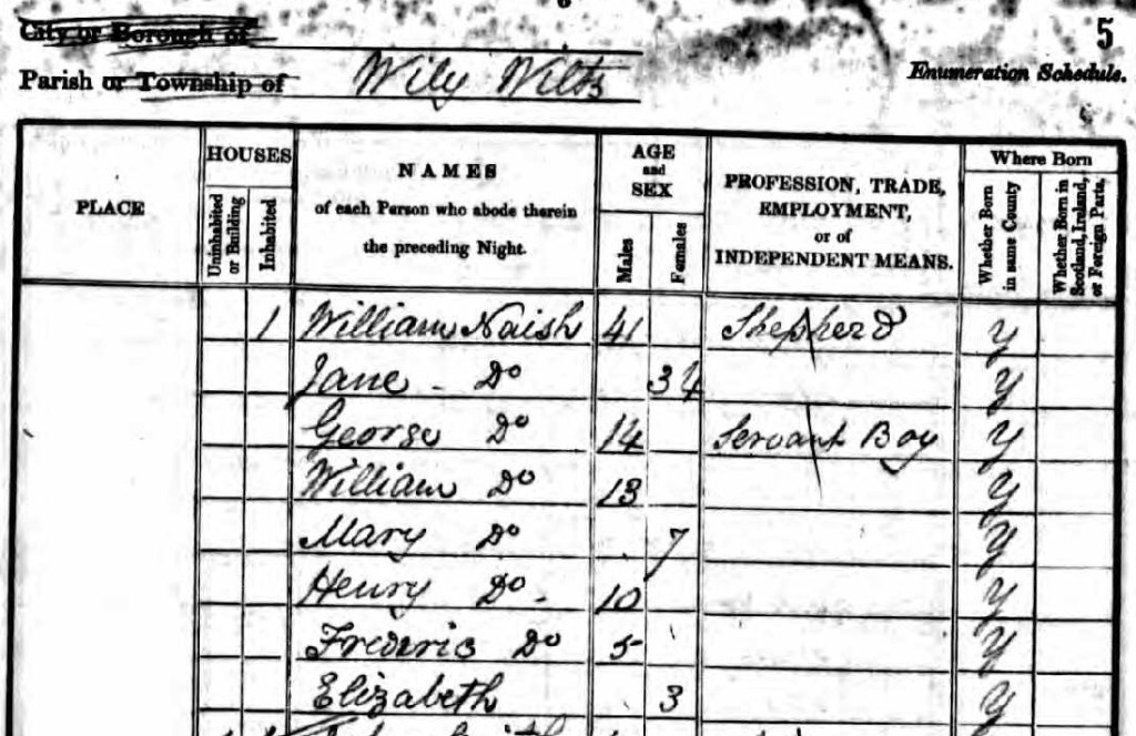
via http://www.ancestry.co.uk
My next step was to search the tithe records on The Genealogist for reference to William Naish. You can search by county, so choosing Wiltshire as the county and Wylye as the parish, there was a single entry for William Na[i]sh:
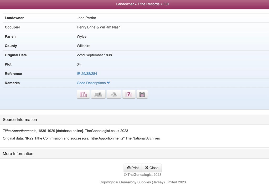
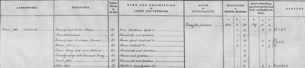
The tithe survey of Wylye was taken on 22nd September 1838. Clicking on the first icon, at the bottom of the summary page, I viewed the actual apportionment that lists William Nash:
Tithe Apportionments, 1836-1929 [database online]. TheGenealogist.co.uk 2023
Original data: “IR29 Tithe Commission and successors: Tithe Apportionments”
The National Archives (U.K.)
John Perrior was the landowner of several properties in the village. Henry Brine and William Nash are the occupiers of tenements and gardens owned by him at Plot No. 34. The amount of land for each plot is measured in acres, roods and perches: there were forty square perches in a rood and four roods in an acre. The land occupied by Messers Brine and Nash consisted of fifteen perches.
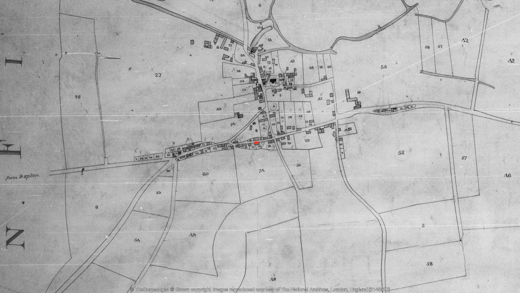
By clicking on the second icon (an open book) on the summary page, you can see the corresponding tithe map, which shows the location of the property, marked on the screen by a pin. The pin may also alert you to relevant Lloyd George Domesday survey records, War Memorials and Headstones, (all sources available on The Genealogist), that are linked to the property. Plot No. 34, where William Naish lived, (along with William Brine), is in the centre of the village on present day Teapot Street:
Tithe Maps, 1836-1929 [database online]. TheGenealogist.co.uk 2023
Original data: “IR 30 Tithe Commission and successors: Tithe Maps”
The National Archives (U.K.)
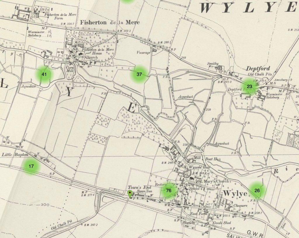
The next step is to use the Genealogist’s Map Explorer, which is a tool that overlays historic georeferenced maps with modern background maps. You can find this by clicking on the third icon on the summary page, a map of the British Isles. Layers of maps are stacked on top of each other. The tithe apportionment map is on the top layer, (which is for record sets). Various ordnance survey maps, ranging from the 1890s to the 1960s, form the historic middle layer. With the use of a slider, the tithe map will fade away to reveal the location of the property (marked with a pin), on your chosen ordnance survey map, some years later:
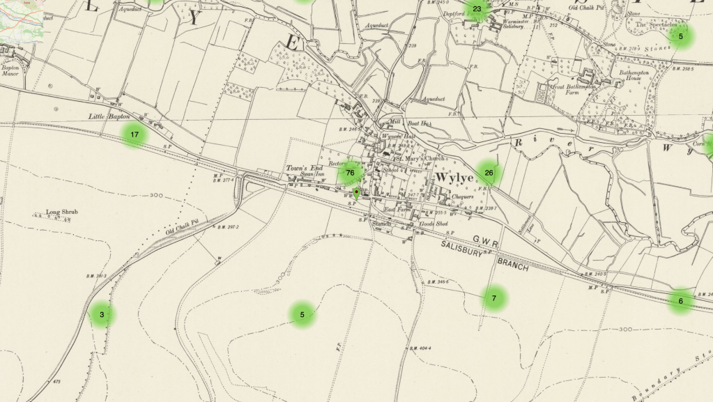
Marked with a green pin on an OS Map dating 1893-1900s
Tithe Maps, 1836-1929 [database online]. TheGenealogist.co.uk 2023
Original data: “IR 30 Tithe Commission and successors: Tithe Maps”
The National Archives (U.K.)
Using a slider again, you can also view the modern base layer map. The Genealogist has Open Street Maps, modern Ordnance Survey maps and Bing maps. The latter provide a road view, a hybrid view and a satellite view. With all the maps, you can zoom in and out to see details more clearly or to get a broader overview of the area.
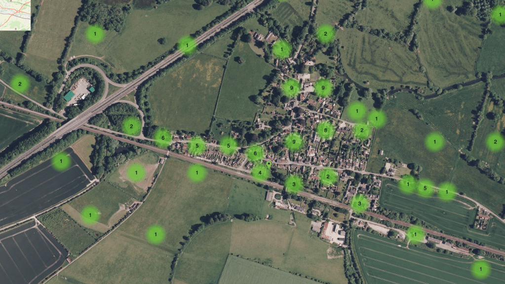
Marked with a green pin on a Bing Satellite Map
Tithe Maps, 1836-1929 [database online]. TheGenealogist.co.uk 2023
Original data: “IR 30 Tithe Commission and successors: Tithe Maps”
The National Archives (U.K.)
You can also use the information to search Google maps, which has Street View:
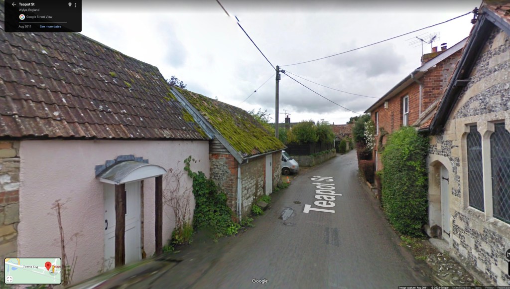
I now know that my ancestor William Naish, the shepherd, lived on Teapot Street, just opposite the chapel, probably where this pink building stands today. Of course, the original house may have been knocked down or altered beyond recognition but it is nevertheless, still meaningful to know the exact spot where he once lived.
The parents of Jane Naish, the wife of William Naish, were Philip Bennett and his wife, Elizabeth. Philip Bennett was a 58 year old labourer and sawyer when the 1841 census, was taken. A search of the tithe apportionment records revealed that Philip Bennett, along with James Harding, was occupying tenements and gardens at Plot No. 14, which consisted of 13 perches. Philip Bennett also had a garden that he cultivated at Plot No. 15. These properties were owned by Lydia Fleming:
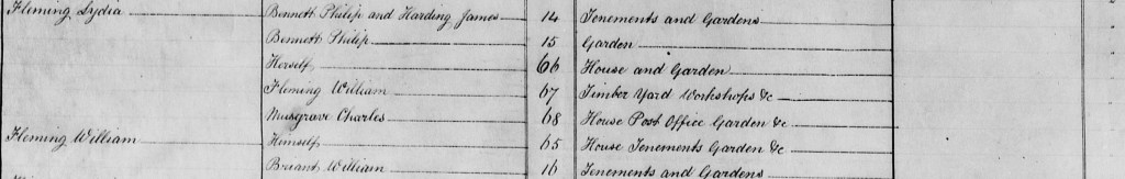
Tithe Apportionment Schedule for Wylye, Wiltshire dated 22nd September 1838
Tithe Apportionments, 1836-1929 [database online]. TheGenealogist.co.uk 2023
Original data: “IR29 Tithe Commission and successors: Tithe Apportionments”
The National Archives
Lydia Fry was the name of Philip Bennett’s grandmother and in Wylye, I know that a number of her female descendants were named after her. After some investigation, I discovered that Lydia Fleming was her great granddaughter, the first cousin once removed of Philip Bennett. She was twenty two years old and living in nearby Stockton with her younger brothers and sisters when the 1841 census was taken. Her parents had died, as had her husband, John Fleming, the previous year. I believe William Fleming was her father in law and he occupied the timber yard and workshops at Plot No. 67. Lydia’s house and garden was situated at Plot No. 66. William Fleming does not appear in the 1841 census and I discovered that he was buried on July 1st 1839, just a year after the tithe survey. The burial record notes that he was a wheelwright. Since Philip Bennett was a sawyer and living in property owned by his cousin, Lydia Fleming, it possible that William Fleming was his employer.
The Ordnance Survey map reveals that the timber yard owned by William Fleming was in the hamlet of Deptford, situated to the north of the Wylye, where the smithy was situated some years later. Philip Bennett’s house, Plot No. 14, was at Town’s End (marked on the map with a green pin). Plot No. 15, where his garden was situated, was next door. If he did indeed work for William Fleming, you can see the likely route he would have taken to get to work in Deptford:
Marked with a green pin on an OS Map dating 1893-1900s
Tithe Maps, 1836-1929 [database online]. TheGenealogist.co.uk 2023
Original data: “IR 30 Tithe Commission and successors: Tithe Maps”
The National Archives (U.K.)
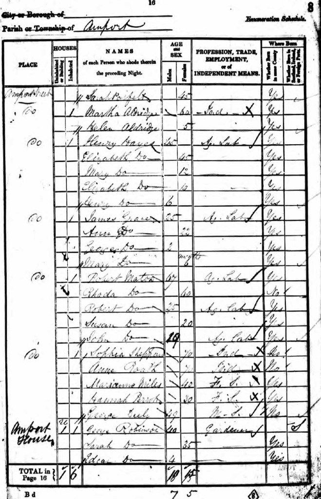
Over the border in Hampshire, my ancestor, Robert Maton, an agricultural labourer, was living with his family in the parish of Amport, near Andover when the 1841 census was taken:
via http://ancestry.co.uk
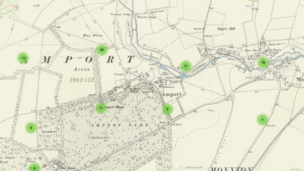
The address given is Amport Street, the main thoroughfare through the village. The census returns suggest that the family lived close to Amport House, the seat of the Marquis of Winchester, who owned most of the land in the village, as this address appears on the same page of the schedule. The Marquis was obviously away from home at the time so just the gardener and servants are listed. The tithe map apportionment records revealed that Robert Mat[i]on occupied gardens at Plot No. 222, along with Thomas Mesh:
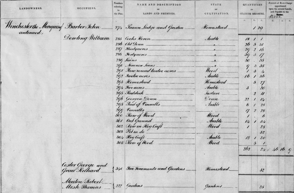
Tithe Apportionments, 1836-1929 [database online]. TheGenealogist.co.uk 2023
Original data: “IR29 Tithe Commission and successors: Tithe Apportionments”
The National Archives
The accompanying tithe map shows the location of Plot No. 222:
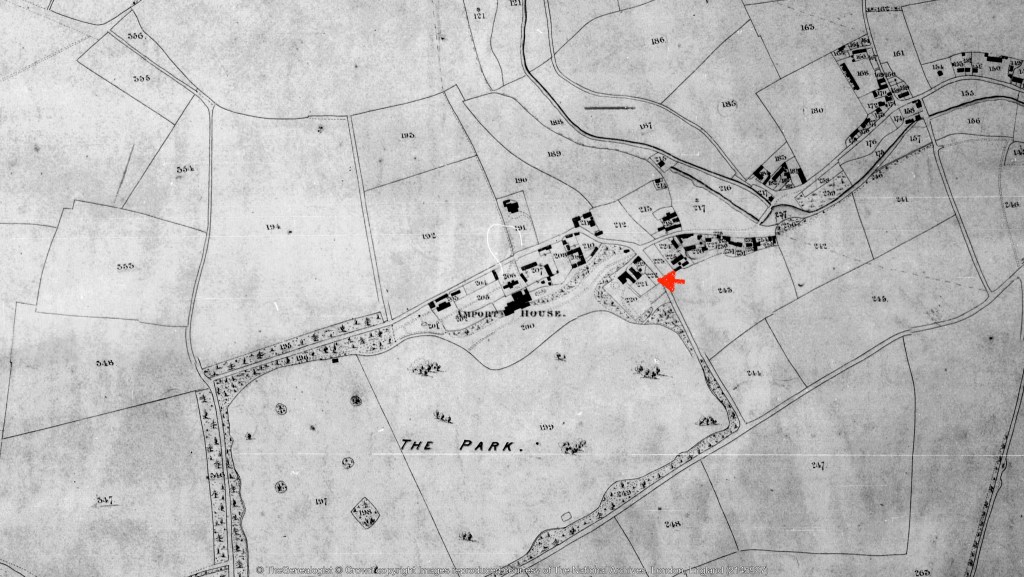
Tithe Map of Amport dated 9th October 1838
Tithe Map of Amport, Hampshire, Tithe Apportionments, 1836-1929 [database online]. TheGenealogist.co.uk 2023
Original data: “IR29 Tithe Commission and successors: Tithe Apportionments”
The National Archives
It is probable that Robert Maton cultivated some vegetables and fruit on a smallholding, perhaps selling any additional produce to help to support his family. You can see from the map that the garden of 32 perches he occupied with Thomas Mesh was very close to the parkland of Amport House. Sophia Sheppard, a local benefactress, who was recorded as his next door neighbour in the 1841 census, owned and occupied the house, garden, lawn and yard adjoining at Plot No. 220. She had a separate garden at Plot No. 221. There is no mention of a house on the plot but the 1841 census returns suggest that the Maton family did actually live here.
A later Ordnance Survey Map shows that Plot No. 222, where Robert Maton had his garden, was later named Amport Firs:
Marked with a green pin on an OS Map dating 1893-1900s
Tithe Maps, 1836-1929 [database online]. TheGenealogist.co.uk 2023
Original data: “IR 30 Tithe Commission and successors: Tithe Maps”
The National Archives (U.K.)
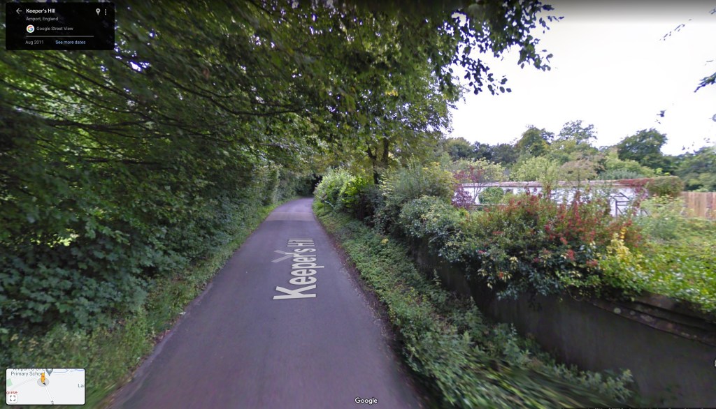
Today, Keepers Hill is the road that leads away from the village of Amport towards Monxton, and the plot of land cultivated by Robert Maton is to the right of the picture:
Altogether, I have found thirteen ancestors listed in the tithe records but five are missing. Two of these ancestors were living in urban areas that were not surveyed because there was little tithable income. The other three were probably not recorded by name in the tithe records because they were subletting a property. For example, Robert Maton’s son, Richard, my direct ancestor, who was also living with his family in Amport when the 1841 census was taken, is not recorded in the Hampshire tithe records. An ancestor is more likely to be missing if they were young and recently married or elderly with no income as in these circumstances, it is more probable that they would be subletting a property. It is worth noting the names of their neighbours in the 1841 census to help pinpoint where they might have lived. There were also a few areas of the country where tithe records do not exist because the land had already been enclosed since one of the purposes of enclosure was to remove the obligation to pay tithes.
Tithe records can also be valuable at much later dates. My two times great grandfather, James Batchelor, his son, George, and my grandfather, Herbert, all appear in tithe records at various dates between 1884 and 1920. This is because changes in ownership and the way the land was subsequently divided up resulted in altered apportionments. These could be formalised at some point and added to the original apportionments. You may also find maps that illustrate the changes that were made.
If your ancestor was a landowner in the tithe records, their wealth and social status can be deduced. Specifically, the amount of tithe payable will be indicative of the value of their landholdings. They are likely to have left a will so tithe records can lead you to fascinating probate records. Wills often describe property holdings in detail and it may be possible to see how the property in question was passed down through several generations of a family. Indeed, you may even find that you have identified the home of your eighteenth century ancestors! Sometimes, the landowner on the tithe apportionment schedule may be recorded as deceased, and the land was in the hands of their executors, all parties being named. Similarly, female owners are sometimes described as widows on the tithe apportionment schedules and their late husband’s name is noted. Relationships can therefore be ascertained.
Bear in mind too that it was not uncommon for people to rent property from relatives. As previously mentioned, Lydia Fleming, the owner of the property in Wylye occupied by my ancestor, Philip Bennett, was his relative. If land was occupied by more than one person, it is possible that they were in business together. Since the tithe records reveal the names of their neighbours, you may even discover that your ancestor married the girl next door!
Information in the tithe records may provide you with clues about the type of land holding. My ancestor, Thomas Shepherd, lived in Bradford upon Avon in Wiltshire and the tithe apportionment schedules for the parish note on occasion if the property was freehold, copyhold or leasehold. There may well be title deeds in local archives that will provide you with more information about the property and how it came into your ancestor’s hands.
At a very simple level, the tithe records are a directory of at least the majority of the heads of household in a parish. The records can therefore be a straightforward means of discovering where a surname can be found in a county. They may also provide evidence of a previous or later residence if your ancestor was living elsewhere when the 1841 census was taken. If your ancestor died prior to the 1841 census, you may find information about them just before their death. As mentioned previously, William Fleming, a wheelwright of Wylye, died just before the 1841 census, but I know where he lived and the location of his timber yard from the tithe records. The use of the land can also provide evidence about an ancestor’s occupation.
As well as for family history, tithe apportionment schedules are invaluable for house history and local history, providing evidence of both property ownership and occupation. You can discover the use of the land in a parish, the acreage of fields, field names, (which may still be in existence today), ancient rights of way, parish boundaries and local topographic features. Even the shape of the property is shown on the tithe maps. The Map Explorer tool offered by The Genealogist enables you to see how the landscape has changed over a period of time.
Above all, I hope I have demonstrated the value of tithe records for locating the home of an ancestor in the early Victorian era. It is very special to visit a village and be able to see where an ancestor once lived and where their children were born. You can retrace their steps and figure out the route would they have taken to walk to school, to church on a Sunday or to the local pub on a rainy evening. Realistically, nearly two hundred years later, the actual building may not have survived but you may find it featured on an old postcard of the village. Even seeing the spot where your family once lived is meaningful. You may be fortunate, and find that the houses of some of their neighbours are still standing. The view they would have seen out of their window may not have changed that much.
© Judith Batchelor 2023
resources
Further detailed information on how to find and search tithe records can be found on The Genealogist:
https://www.thegenealogist.co.uk/researchguide/unique-resources-855/#873
The tithe records form part of The Genealogist’s Diamond subscription. A free 14-Day trial to their website is also available.
The National Archives also provides a useful guide on tithe records:
https://www.nationalarchives.gov.uk/help-with-your-research/research-guides/tithes/
The tithe records for the whole of Wales have been put online by the National Library of Wales:
English Counties
There are online tithe records for many counties in England:
Cheshire:
https://www.cheshirearchives.org.uk/latest-news-and-events/Cheshire-Tithe-Maps-Online.aspx
Cornwall:
Derbyshire:
https://www.derbyshire.gov.uk/leisure/record-office/records/historic-maps/historic-maps.aspx
Devon:
https://www.devon.gov.uk/historicenvironment/tithe-map/
Dorset:
https://www.ancestry.co.uk/search/collections/2386/
County Durham:
https://familyrecords.awh.durham.ac.uk/tithe.html
East Sussex + Brighton and Hove:
https://apps.eastsussex.gov.uk/leisureandtourism/localandfamilyhistory/tithemaps
Gloucestershire:
Hampshire (on CD-Rom):
https://www.hants.gov.uk/librariesandarchives/archives/popular-records/maps-plans
Kent:
https://www.kentarchaeology.org.uk/search?q=tithe
Oxfordshire (Maps only):
https://www.oxfordshirehistory.org.uk/public/maps/tithe/tithe_maps.htm
Warwickshire (Apportionments only):
https://heritage.warwickshire.gov.uk/catalogues-databases/tithe-appointments-database
Worcestershire (Maps only):
https://gis.worcestershire.gov.uk/website/tithesmapping/
Yorkshire (West Riding):


Great post…I did a trial with TG a few years ago and grabbed a couple of tithe records and maps. Have now found more people to research, so hope at some point to do a short sub with them to grab some more. Alas, our geriatric cat has eaten up a good deal of my genealogy budget recently, but she’s worth it…it’s not like my ancestors are going anywhere, nor are their records (I hope).
LikeLiked by 1 person
The Genealogist website is a dream to use but there are some other options, depending on the county. I’m sure your cat is worth the investment.
LikeLike
An absolute master class from Jude a real lesson and journey for all of us. Thanks Jude for sharing such a comprehensive insight into how to find your ancestors homes using the Tithe maps
LikeLiked by 1 person
Thank you for your generous comment. I hope you have some fun finding your own ancestors in tithe records.
LikeLiked by 1 person
Another brilliant post, Jude, that I will certainly refer back to. I have looked at tithe records for my current house but unfortunately no tithe map exists for my village, Drayton. Archivists at Berks Archives say this may be because the village was a chapelry of a parish in the nearest town or because tithes there had already been extinguished by enclosure. However, this has inspired me to look at more tithe records for my ancestors as well.
LikeLiked by 1 person
To be clear, I mean I looked FOR tithe records for my house.
LikeLiked by 1 person
Thanks for your kind comment Clare. It’s a shame that there is no tithe map for your village but hopefully you will find some ancestors that feature in tithe records elsewhere.
LikeLike
wow. Great work. I recently found a parish tithing list from Morchard Bishop area, northwest of Exeter. I found references to family plots but can’t see many details. Tithing plot numbers are hard to read, even on maps produced in 2015 for the same area as a conservation zone. I’m crappy at genealogy and get frustrated by all the spelling, date, and other record errors. Still, what you write here is encouraging. Thanks.
LikeLiked by 1 person
Nice to get your message. With tithe records you need to match the number on the apportionment with the map to identify an ancestor’s property. If the record is digitised, zooming in can help with legibility. Best of luck!
LikeLike